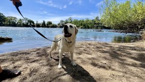
The El Dorado Trail stretches approximately 35 miles between Placerville and the Camino area of Northern California, offering a scenic route or pedestrians, cyclists, and equestrians. With a gentle 2% grade this trail provides an easy spot for dog walking. The Camelia Lane Entry is just one of many access points to the trail.
The County is actively developing this trail within the old Michigan/California Railroad right-of-way. Dogs must be on a 6-foot or shorter leash. Dog waste bag dispensers are available along the trail.
Directions:
Exit Point View Drive and go north, continuing on Jacquier Road (the main road.) You will see the sign for the El Dorado Trail on your right at the corner of Jacquier Road and Camelia Lane.

For best-in-show fun, it’s hard to top California’s sunny capital city. Sacramento is a pup-culture powerhouse with trails, wineries, breweries and farm-to-table restaurants framed by...
Read More

Sacramento’s big backyard offers more adventures like chasing waterfalls in Placer County, tracing old mining trails near the American River, or wine tasting in the...
Read More

With a thriving craft beer scene and easy access to top wine producers, Sacramento is a tasting tour hotspot.
Read More

Sacramento’s status as “America’s Farm-to-Fork Capital” comes from its proximity to more than 1.5 million acres of farmland that support some 160 crops. Nearly area...
Read More

DogTrekker readers love Sacramento’s parks and multi-use trails. The 32-mile American River Parkway might be the best known, and it’s also worth visiting the paths...
Read More
DogTrekker.com launched 15 years ago, guided by a mission to leave no dog behind – whether at home, while traveling, or in shelters. Since June 2011,...
Read More