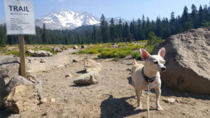
It takes just half an hour to drive Everitt Memorial Highway, a two-lane, 14-mile scenic road up the southwest flank of Mount Shasta. Or then again, it can take all day. If you’re into climbing, the names “Panther Meadows,” “Bunny Flat” and “Old Ski Bowl” have resonance; they’re all starting points for snow-season climbs of the majestic, 14,161-foot volcanic cone that dominates the landscape for miles around.
The road is usually drivable from late June until late October, when snow closes it above Bunny Flat.
You’ll find restrooms by the roadside at Bunny Flat and Panther Meadows, along with first-come campgrounds. Dogs are allowed on the Old Ski Bowl trails at the end of the highway and on Gray Butte Trail in the Panther Meadows area, but nowhere else in the Mount Shasta Wilderness.
The highway starts in Mount Shasta City but is not well marked. Take Lake Street from the center of town, bend onto Chestnut, pass the high school and you’re good to go.


