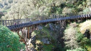
The Independence Trail had its origins as the Excelsior Canal, a five-foot-wide aqueduct exceptionally engineered in 1859 to carry water for hydraulic mining all the way to Smartsville, 25 miles away.
The almost-level ditches and flumes skirting extremely steep hillsides and bridging deep ravines were restored with the help of the nonprofit Sequoya Challenge to become the first wheelchair-accessible wilderness trail in the country.
The trail’s flat surface and easy grade makes it popular with moms pushing strollers and older folks looking for a nature hike, as well as hard-body hikers using it as a jumping-off point for more difficult pursuits.
From the trailhead on Highway 49 approximately five miles north of Nevada City and a mile before the first bridge crossing the South Yuba, crossing, hikers can choose to follow the trail either two miles downstream (west) or two miles upstream (east).
The first 1.5 miles in either direction are wheelchair accessible except after heavy rains. There are many splash spots along the way. One of the scenic highlights on the west side of the trail is a 520-foot switchback ramp.
Hardy hikers and their four-legged friends can continue past the end of the trail to swimming holes in the Jones Bar area.
The Independence trail is part of South Yuba River State Park, which stretches in patchwork fashion for 20 miles along the waterway.


