Gold Country is best known for its Gold Rush history, but this stretch of the Sierra Nevada foothills also holds some of California’s most rewarding accessible trails — places where handlers with mobility needs and their dogs can explore paved paths, historic flumes, and lakeside routes without barriers. From the nation’s first wheelchair-accessible wilderness trail near Nevada City to flat, paved parkways threading through the American River canyon, we’ve compiled the best ADA accessible, dog-friendly trails across the region. For accessible trails beyond the foothills, see our statewide guide to ADA accessible trails.
A note on service dogs: Under the Americans with Disabilities Act, service dogs are permitted on all public trails — even where pet dogs may be restricted. We’ve focused here on trails that welcome both service dogs and leashed pet dogs, but if a trail limits pet access, service dog handlers retain full legal access. More on that below.


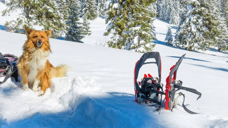
Independence Trail, Nevada City
The Independence Trail holds a singular distinction: it was the first wheelchair-accessible wilderness trail in the United States. Naturalist John Olmsted converted the old Excelsior Ditch — an 1859 mining flume built to carry water for hydraulic gold mining — into a level, accessible path through the South Yuba River canyon in the 1970s. The trail branches east and west from a trailhead on Highway 49 about six miles from downtown Nevada City, with the first 1.5 miles in each direction constructed for wheelchair access. Two parallel paths run side by side: a wider surface for wheelchairs and a narrower hiking path alongside it.
Dogs are welcome on leash throughout the trail. The west side features an impressive 520-foot switchback ramp with sweeping canyon views, while the east section winds through quieter forest. Because the trail follows a historic mining ditch, the grade stays remarkably flat — a genuine rarity in the Sierra foothills. Some sections may become less passable after heavy rain, so we recommend checking conditions with the Bear Yuba Land Trust before visiting during the wet season. Note that Independence Trail West sustained fire damage in recent years and sections may be closed; Independence Trail East remains open and accessible.
Truckee River Legacy Trail, Truckee
The Truckee River Legacy Trail is a paved, flat path that runs roughly five miles along the Truckee River, connecting downtown Truckee with the Glenshire neighborhood. The smooth asphalt surface is 8 to 10 feet wide, making it fully navigable for wheelchairs, mobility devices, and strollers. What sets this trail apart in the mountains is year-round access — the path gets plowed in winter, so we can walk it even when snow blankets the surrounding peaks.
Dogs must stay on leash, and you’ll find plenty of company from other dog walkers, runners, and cyclists. The trail passes a bridge over Martis Creek at roughly the midpoint, which makes a natural turnaround if you want a shorter outing. River views are consistent throughout, and the gentle grade means the trail works for dogs of all ages and abilities. The trailhead at Truckee River Regional Park has parking and restroom facilities. Bring water, as there are limited amenities along the route itself.
Lakeside Interpretive Trail, Donner Memorial State Park
Inside Donner Memorial State Park, the Lakeside Interpretive Trail follows the south shore of Donner Lake for 1.37 miles each way on a compacted aggregate surface graded for mobility devices. The trail is generally flat at less than 5% grade, with a few intermittent sections between 5% and 8%. Accessible parking and ADA-compliant restrooms are available at the visitor center.
Dogs are allowed on the Lakeside Interpretive Trail, on the Zig Zag Trail, on fire roads, and along the Donner Lake shoreline — but not on China Cove Beach, the Nature Trail, or inside the visitor center. Leashes of six feet or shorter are required. The trail offers views across Donner Lake to the surrounding granite peaks, and interpretive signs along the route tell the story of the Donner Party and Sierra Nevada ecology. The compacted surface is usable year-round except when obstructed by snow, so spring through fall is the most reliable window. Call (530) 582-7892 for current conditions before visiting.
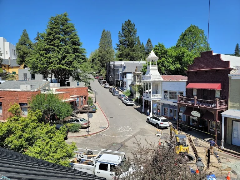
El Dorado Trail, Placerville
The El Dorado Trail follows the old Michigan-California Railroad right-of-way through Placerville, offering a paved, nearly flat route with a maximum grade of just 2%. The City of Placerville section runs 4.3 miles of smooth asphalt from Jacquier Road to the Ray Lawyer Drive Park and Ride, with the trail typically at least eight feet wide. Designated ADA-accessible parking with van-accessible spaces and striped aisles is available at the Missouri Flat Road trailhead.
Dogs are welcome on leash (six feet or shorter), and dog waste bag dispensers are placed along the route. The trail passes through oak woodland and open meadow as it climbs gently through the El Dorado County foothills — the kind of walk where you barely notice the elevation change. The railroad heritage means no sharp turns or sudden grade changes, which is exactly what makes it so reliable for wheelchair and mobility device users. We recommend the Missouri Flat to Placerville section for the smoothest, most consistently paved experience.
Dave Moore Nature Area, Coloma
Managed by the Bureau of Land Management, the Dave Moore Nature Area sits about two miles west of Marshall Gold Discovery State Park in Coloma. The mile-long loop trail passes through several Sierra foothill habitats on its way to the South Fork of the American River. The section from the restroom trailhead to the river and back is wheelchair and stroller accessible, with flat, well-maintained surfaces — though the full loop includes natural-surface sections that are not fully accessible.
Dogs must stay on leash. The trail threads past Gold Rush-era tailings piles and “Mushroom Rock,” a pair of stacked granite boulders shaped by centuries of river erosion. It’s a genuinely interesting walk that combines geology, mining history, and riparian habitat in under a mile. The area is free to enter and open daily from 8 a.m. to sunset. Parking is available at the trailhead, though the lot is small. The accessible portion works well as an out-and-back to the river, where you can enjoy the water before turning around.
Miners Ravine Trail, Roseville to Granite Bay
The Miners Ravine Trail runs nearly nine miles round trip as a paved out-and-back route following Dry Creek through Roseville and into Granite Bay. The asphalt surface is 10 feet wide with two-foot shoulders and a painted center line separating pedestrian and bicycle traffic. The entire trail stays in the mostly gentle (5% or less) grade category, making it navigable for most wheelchairs and mobility equipment.
ADA-accessible van parking is available at both ends: two designated spaces at the Sierra College Boulevard trailhead and four at the Oak Street lot, all with striped access aisles. Dogs must be leashed, and you’ll find the trail well-used by other dog walkers, especially on weekends. The out-and-back format means you can turn around at any point — many people do three or four miles rather than the full distance. Spring wildflowers line the creek corridor, and the flat terrain makes this one of the most reliably accessible long trails in Placer County. Bring water, as shade is limited in some stretches.
Tahoe City Lakeside Trail, Tahoe City
The Tahoe City Lakeside Trail is a one-mile paved waterfront promenade connecting Commons Beach to the Tahoe City Marina along the north shore of Lake Tahoe. The trail is completely flat and paved, making it suitable for wheelchairs, mobility scooters, and strollers. Several overlooks and small plazas along the route provide stopping points with views across the lake to the Sierra crest.
Leashed dogs are welcome on the trail (though not in the lake). The path links naturally to the larger 19-mile North Shore bike path system, so you can extend your walk in either direction if you want more distance. Downtown Tahoe City’s dog-friendly restaurants are steps away, making it easy to combine a trail walk with a meal. Parking is available at Commons Beach and near the marina. Morning visits are quieter, but the trail is wide enough that it rarely feels crowded even during peak summer afternoons.
American River Parkway, Sacramento to Folsom
The American River Parkway — also known as the Jedediah Smith Memorial Trail — stretches 32 miles along the American River from Discovery Park in Old Sacramento to Beal’s Point at Folsom Lake. The two-lane paved trail is at least 10 feet wide with a smooth asphalt surface and stays at a gentle grade of 5% or less throughout. ADA-accessible parking, van-accessible spaces, and wheelchair-accessible restrooms are available at multiple trailheads along the route.
Dogs must be leashed. With 82 miles of branching side trails, the parkway offers far more variety than a typical paved path — shaded forest sections, open grassland, and river access points break up the scenery throughout. The eastern sections near Folsom sit within Gold Country proper, where the foothills begin to rise and the landscape shifts from valley floor to oak-studded canyons. We recommend the stretch from Beal’s Point westward for the best combination of accessible pavement, river views, and Gold Country scenery. Mile markers, water fountains, and benches are spaced along the route, though we still suggest bringing extra water on warm days.
Dragoon Gulch Trail, Sonora
The Dragoon Gulch Trail system in Sonora creates a 2.5-mile loop starting from Woods Creek Park in the center of town. While the full loop includes natural-surface sections, the South Creekside Trail is ADA accessible from the Alpine Lane parking lot, with a gentle 1.5% slope for 1,242 feet. The North Forest Trail segment is also paved, giving mobility device users two accessible options within the system.
Dogs are welcome on leash. The trail winds through manzanita and oak woodland along a natural creek, climbing to a vista point with panoramic views of Sonora and the surrounding Sierra foothills. For wheelchair users, we recommend starting at the Alpine Lane trailhead, which has designated ADA trail access and the smoothest approach to the creekside section. The trail is free to use and open dawn to dusk. Sonora sits at about 1,800 feet elevation in the heart of the southern Gold Country, so temperatures tend to be moderate in spring and fall — the best seasons for a visit.
Know your rights on the trail
Under the Americans with Disabilities Act (ADA), service dogs are permitted in all public spaces, including trails, parks, and beaches — even where pet dogs are prohibited. California’s Unruh Civil Rights Act and Disabled Persons Act extend these protections further. A service dog must be under the handler’s control (leash, harness, or voice command) and housebroken. Businesses and park staff may ask only two questions: (1) is this a service animal required because of a disability, and (2) what task has the dog been trained to perform. They may not ask about the handler’s disability, require documentation, or charge extra fees.
Planning your accessible trail visit
Gold Country spans a wide range of elevations — from the Sacramento Valley floor near Roseville (about 160 feet) to the Sierra crest above Donner Pass (over 7,000 feet). That elevation range means weather and trail conditions can vary dramatically even on the same day. Foothills trails around Placerville, Coloma, and Sonora are generally accessible year-round, though summer temperatures can climb above 100 degrees at lower elevations. Trails near Truckee and Lake Tahoe may be snow-covered from November through April, and even paved trails like the Truckee River Legacy Trail can have icy patches in early morning during winter months.
We always recommend calling the managing agency before visiting to confirm current trail conditions, especially after storms or during spring snowmelt. Compacted aggregate surfaces like the Lakeside Interpretive Trail can soften after rain, and paved trails at higher elevations may have frost heaves or debris that affect wheelchair access. Bring layers — Sierra weather can shift quickly, with afternoon thunderstorms common in summer and temperatures dropping sharply after sunset. Carry more water than you think you’ll need, both for yourself and your dog, since many of these trails have limited shade and few water sources along the route.