The Yosemite region and Eastern Sierra offer some of California’s most stunning mountain scenery — and the good news is that several trails in the area are accessible for visitors with mobility challenges who want to bring their dogs along for the adventure. Whether we’re talking about a paved creekside stroll in Mammoth Lakes or a wheelchair-friendly path to one of Yosemite’s iconic waterfalls, these trails prove that accessibility and dog-friendly outdoor fun aren’t mutually exclusive. For more options across the state, check out our statewide guide to ADA accessible trails.
A note about service dogs: Under the Americans with Disabilities Act, service dogs are welcome everywhere — including national parks and trails where pet dogs may be restricted. We’ve noted pet dog policies for each trail below, but handlers with service dogs always have full access regardless of pet restrictions.


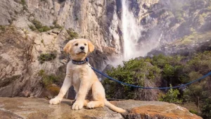
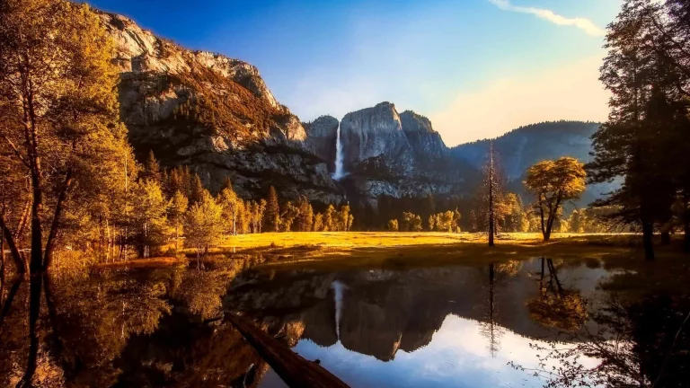
Lower Yosemite Falls loop (Yosemite National Park)
Before we venture into the trails surrounding the park, it’s worth knowing about one accessible option inside Yosemite National Park itself. Dogs in Yosemite are limited to paved roads, paved paths, and developed areas — they are not allowed on unpaved trails, in meadows, or on shuttle buses. That said, the Lower Yosemite Falls loop is one place where leashed dogs and accessibility meet beautifully. This one-mile paved loop leads to the base of Lower Yosemite Fall, one of the most photographed waterfalls in the world. The trail surface is paved asphalt and wooden boardwalk, typically at least four feet wide, with edge barriers along much of the route. The grade is mostly gentle at five percent or less, though some moderately steep sections (five to eight percent) and a few steeper pitches (eight to twelve percent) may require assistance. A free wheelchair-accessible shuttle stops nearby at shuttle stop #6, and accessible restrooms and a water fountain are available at the trailhead. Visit during spring for the most dramatic water flow.
Shady Rest Path and park (Mammoth Lakes)
One of the most popular paved paths in Mammoth Lakes, the Shady Rest Path meanders gently downhill through a forest of red fir and Jeffrey pine, connecting to the ball fields, playground, and picnic area at Shady Rest Park. The two-lane paved multi-use path is part of the Mammoth Lakes Trail System and is well suited for wheelchairs, adaptive bikes, and strollers. At the park itself, we’ll find playground equipment, a sheltered picnic area, restrooms, and plenty of room for a leashed dog to enjoy the mountain air. The path is approximately 0.8 miles and connects to the Old Shady Rest and New Shady Rest campgrounds as well as the Mammoth Lakes Welcome Center. Situated at the end of Sawmill Cutoff Road, just a short half-mile from Highway 203, Shady Rest is open from approximately May through November 1, weather permitting. At 7,800 feet elevation, the air is thin but the pine-scented forest is worth every breath.
Mammoth Creek Park and the Town Loop (Mammoth Lakes)
For a longer paved adventure, Mammoth Creek Park on Old Mammoth Road serves as an excellent starting point for the Town Loop, a 7.3-mile paved multi-use path that forms the hub of the entire Mammoth Lakes Trail System. From the park, the path heads east to a scenic lookout point with views of Sherwin Ridge, Laurel Mountain, and Valentine Peak — a two-mile round trip if we turn back at the viewpoint. The park itself features grassy picnic areas, restrooms, parking, dog bag dispensers, and good creek access for wading on warm days. Leashed dogs are welcome throughout. While the full Town Loop does include some hilly sections, the paved surface accommodates adaptive bikes and wheelchairs, and visitors can choose shorter, flatter segments. The park is open mid-May through early November, weather permitting, and the playground equipment and shaded creek make it a wonderful spot to rest during a longer outing.
Convict Lake accessible trail (near Mammoth Lakes)
Surrounded by the dramatic peaks of the eastern Sierra — including towering Mt. Morrison — Convict Lake is one of the region’s most scenic destinations, and it offers genuine accessibility. A paved nature trail provides easy access to the east side of this deep blue alpine lake, with the first 0.3 miles of the path fully accessible for visitors using wheelchairs, mobility equipment, or strollers. An ADA-accessible fishing pier extends over the water, offering anglers of all abilities a chance to cast a line in one of the Eastern Sierra’s best trout fisheries. Benches are placed along the route for resting and soaking in the views. Leashed dogs are welcome on the paved trail and on the full 2.5-mile loop that circles the lake for those who want to continue on the unpaved portions. Restrooms and trash receptacles are available near the parking area. The lake sits at approximately 7,850 feet elevation, about 10 miles south of Mammoth Lakes off Highway 395. The Convict Lake Campground nearby makes this a great base for a multi-day accessible adventure.
Devils Postpile trail (Mammoth Lakes area)
One of the Eastern Sierra’s geological wonders, Devils Postpile National Monument protects a striking formation of columnar basalt that rises 60 feet high. The trail from the main trailhead to the base of the Postpile is approximately half a mile each way with about 40 feet of elevation change — a wheelchair-friendly route that brings visitors face to face with this natural marvel. Leashed dogs are permitted on all trails within the monument, a notable exception to the typical national monument pet restrictions. Dogs are also allowed on the mandatory shuttle buses that run during peak season (generally mid-June through early September), though they must wear muzzles while aboard. The monument sits at about 7,560 feet elevation in a gorgeous stretch of the Middle Fork San Joaquin River valley. For those with more mobility, the trail continues another 1.5 miles to Rainbow Falls, though that section is steeper and less accessible. The Inyo National Forest surrounding the monument offers additional dog-friendly recreation opportunities.
Horseshoe Lake loop (Mammoth Lakes Basin)
Nestled at the end of Lake Mary Road at 8,960 feet elevation, Horseshoe Lake is one of Mammoth Lakes’ best-loved dog destinations. The 1.8-mile loop trail circumnavigates the lake on a combination of native-dirt path and paved multi-use path, with about 120 feet of elevation gain. While the full loop includes unpaved sections, the paved Lakes Basin Path portion along the north side of the lake provides a smooth, accessible segment with views across the water to the Mammoth Crest. The trail follows the lakeshore around the south side and then meanders through lodgepole pine forest before connecting back to the paved path. Leashed dogs are welcome and will appreciate the easy lake access for a cool-down dip. The Mammoth Lakes Trail System lists an adaptive option for this trail, making it a viable choice for visitors using adaptive equipment on the paved segments. A parking area and restrooms are available at the trailhead.
Bishop City Park (Bishop)
In the heart of the Owens Valley at about 4,150 feet — making it the most altitude-friendly option on this list — Bishop City Park offers a paved path that winds under shady trees, follows a burbling creek, circles a pond, and leads out to a gazebo. The park features an off-leash dog area where four-legged companions can stretch their legs freely, and the paved pathways throughout are wheelchair accessible. From the park, safe sidewalks connect to downtown Bishop’s shops, restaurants, and the vibrant main street. Bishop serves as the gateway to the Eastern Sierra’s most dramatic landscapes, and the park’s lower elevation means a longer season and warmer temperatures compared to Mammoth Lakes. This is an ideal spot for visitors who want to enjoy the Eastern Sierra outdoors without the challenges of high-altitude trails, and it makes a perfect rest stop on a Highway 395 road trip with your dog.
Lakes Basin Path (Mammoth Lakes)
For experienced wheelchair users or visitors with adaptive bikes looking for a longer challenge, the Lakes Basin Path is a 5.3-mile paved multi-use path that connects the North Village area of Mammoth Lakes to Horseshoe Lake, passing some of the region’s most spectacular alpine scenery along the way. The path passes Twin Lakes, Tamarack Lodge, Lake George, and Lake Mamie. We should note that this trail is more demanding than others on this list — the estimated grade is moderately steep at five to eight percent, with very steep sections exceeding 12 percent grade at several points. The total elevation change between Horseshoe Lake and the North Village is about 1,000 vertical feet, so downhill travel requires speed control. Leashed dogs are welcome on the entire path. The paved surface is asphalt, typically at least eight feet wide with a yellow center line. To avoid the steepest sections, we recommend using the free Lakes Basin Trolley to access different points along the route and choosing shorter, flatter segments to explore.
Know your rights on the trail
Under the Americans with Disabilities Act (ADA), service dogs are permitted in all public spaces, including trails, parks, and beaches — even where pet dogs are prohibited. California’s Unruh Civil Rights Act and Disabled Persons Act extend these protections further. A service dog must be under the handler’s control (leash, harness, or voice command) and housebroken. Businesses and park staff may ask only two questions: (1) is this a service animal required because of a disability, and (2) what task has the dog been trained to perform. They may not ask about the handler’s disability, require documentation, or charge extra fees.
Planning your accessible trail visit
The Eastern Sierra demands a bit more planning than lower-elevation destinations in California. Most trails on this list sit between 7,500 and 9,000 feet in elevation, where thinner air can affect energy levels — especially for visitors arriving from sea level. We recommend taking a day to acclimate before hitting the trails, staying well hydrated, and watching for signs of altitude sickness.
The hiking season at higher elevations is short, generally running from mid-June through October, though snow can linger on shaded paths well into July and early storms can arrive by late September. Highway 120 (Tioga Pass) and several other mountain roads close for winter, and facilities like Devils Postpile operate only during the summer shuttle season. Bishop, at 4,150 feet, offers a much longer season and is accessible year-round.
Services can be limited in the Eastern Sierra, so we recommend carrying extra water, snacks, and sun protection. Cell service is spotty outside of town centers. For the most current trail conditions and accessibility information, check with the Mammoth Lakes Welcome Center, the Bishop Visitor Center, or the Inyo National Forest ranger stations before heading out. Hot pavement can burn dog paws in summer — early morning outings are best during July and August.